
Ride Reports
2009 Harley-Davidson Touring Chassis

All new Harley-Davidson touring chassis.
Please copy and paste the following HTML snippet in order to ensure success:
Latest Photos
Recently Added Photos
Latest motorcycling-related photos

2011 IMS - Harley Girls
Harley-Davison girls at the 2011 IMS show in San Mateo, California.
See the big picture »
Captain America - 1942 Harley Davidson WLA Liberator
Captain America rides a 1942 Harley Davidson WLA "Liberator" in the Marvel Studios movie being released 7.22.11.
See the big picture »
Fulmer AF-6B Helmet - Flat Black
The Fulmer AF-6B Helmet in flat black. Photo courtesy of Fulmer Helmets. Read the Fulmer AF-6B helmet review for more information.
See the big picture »

2011 Ducati Diaval Carbon - Right Rear 3/4
2011 Ducati Diavel Carbon in "black carbon".
See the big picture »


All Time Popular Photos
All-Time Popular Photos
We never know what visitors are looking for. Now you do.

Umbrella Girls USA - at the 2007 Red Bull U.S. Grand Prix
Umbrella Girl USA
A motorcycle race would not be complete without the lovely Umbrella Girls. There was quite a crowd surrounding their booth at the ...
See the big picture »
Glamour Girls Swimsuit Calendar Models at the 2008 Easyriders Show in Sacramento, ...
Easyriders Models There were quite a few sexy models strutting their stuff at the 2008 Easyriders show.
The Glamour Girls Swimsuit Calendar models were posing for photos ...
See the big picture »
Raven R6 Yamaha Wheelie
Nice Yamaha R6 in Raven color scheme. Nice wheelie too!
See the big picture »

Buell Rat Bike Custom @ 2007 Easyriders Sacramento Show
Buell Rat Bike/Rat Rod Style This image was uploaded with the post Buell Rat Rod Custom @ 2007 Easyriders Sacramento Show.
See the big picture »
2008 MotoGP - Ducati Girl
The Ducati girl smiles for the camera on Ducati Island.
See the big picture »
2009 Harley-Davidson - FXDB Dyna Street Bob
2009 Harley-Davidson Street Bob in Dark Blue Denim.
See the big picture »
2010 Harley-Davidson FXDWG Dyna® Wide Glide®
The new Wide Glide® is a Dyna® Big Twin done up old-school chopper style - a low, stretched-out custom with drag bars and forward foot ...
See the big picture »
2007 Harley Davidson - Dyna Street Bob
2007 Harley Davidson FXDB Dyna Street Bob in the new color Olive Pearl.
See the big picture »
Harley Davidson - Night Train
2007 Harley Davidson FXSTB Night Train at McGuire Harley-Davidson. Visit their show rooms in Walnut Creek and Pittsburg, California.
See the big picture »
2008 Arlen Ness Bike Show - Road Rage Girl
Road Rage apparel had a nice presentation.
See the big picture » - Portrait")
2008 AMA Finale - Harley-Davidson Girl (I) - Portrait
Harley-Davidson had several bikes and girls outside their rider lounge.
See the big picture »
Carl Boling's Custom Hot Candy Apple Harley-Davidson
Carl Boling's Hot Candy Apple Harley-Davidson featuring a pair of beautiful models. Taken at the Renegade Classics Custom Bike Shoot Out 2009 show at ...
See the big picture »
2008 MotoGP - Valentino Rossi - Saturday Qualifying
Valentino Rossi seems to be flying low on his Fiat Yamaha Team YZR-M1 800cc MotoGP bike in Saturday qualifying at Mazda Laguna Seca Raceway.
See the big picture » - Portrait")
2008 AMA Finale - Harley-Davidson Girl (II) - Portrait
Harley-Davidson Girl poses outside the rider lounge.
See the big picture »
Hot Wheels Gallery I
The Snake II Hot Wheels Full Size Model One of the cars in the Hot Wheels Gallery at the Petersen Museum. If you are a ...
See the big picture »2011 IMS - Harley Girls
Harley-Davison girls at the 2011 IMS show in San Mateo, California.
See the big picture »
2008 Easyriders Show - Hooters Girls
The Hooters girls pose for RoadCarvin. Cold beer, tasty food, and beautiful servers, my kind of place.
See the big picture »
2007 Harley-Davidson Screamin' Eagle VROD
2007 Harley-Davidson Screamin' Eagle VROD in Orange and Silver.
See the big picture »
2009 Harley-Davidson Road King Classic - Pacific Ocean
2009 Road King Classic, Deep Turquoise/Antique White on the California Coast. Photo by Kevin Wing.
See the big picture »
Five In A Row at the 2008 Sacramento Easyriders Show
Five young ladies pose for the camera (and create a massive distraction) at the 2008 Easyriders show in Sacramento, California.
See the big picture »
2007 Cycle World IMS - 2008 KTM LC8 Engine Cutaway
Engine cutaways are alway fun to look at and this KTM LC8 is very cool. I like the straight intake to the cylinder.
See the big picture »
2008 Rolex Monterey Historic Races - 1976 Tyrrell P34 - Turn 8
1976 Tyrrell 6 wheel Furmula 1 car originally driven by Patrick Depailler.
See the big picture »
Duct Tape Use Case #7,624,123 - Holding Your Car Together After A ...
A friend sent this to me a while ago, so I thought I'd get off my duff and post it. It was taken in ...
See the big picture »Independence Day Sierra Ride - Highway 88, Markleeville, Ebbets Pass to Angels Camp
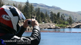
July 5th 2008 was a beautiful early summer day, and a fine time to take a ride up Highway 88, through Markleeville, over Ebbets pass, and down to Bear Valley and beyond.
The weather was perfect if a bit on the warm side as we prepared for departure. Temperature was about 90 degrees Fahrenheit in Pine Grove at about 9:30 AM, and it cooled rapidly as we gained altitude. Smoke from the recent California fires lingered at 2,400 feet elevation. Barely 40 minutes later, we were in cool and mostly clean air, almost completely devoid of the smoke that plagued the lower elevations over the last few weeks. Some haze remained but it didn't seem much worse than on other visits over the years.
Click here to continue...The Road Beckons

Independence Day Ride - CBR954RR on Highway 4
Dwight's Honda CBR954RR seems eager to get back on the road -- it's as if the red and black beast is saying: "Come on, let's get going!"
In case you didn't notice from the photo, Highway 4 is in great condition over Ebbets Pass.
Please copy and paste the following HTML snippet in order to ensure success:
Independence Day Ride - Scenic Overlook - Tree

This twisted dead tree caught our attention and we had to take some pictures.
Please copy and paste the following HTML snippet in order to ensure success:


